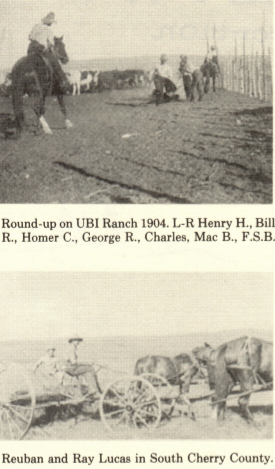
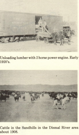
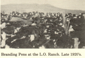
HOOKER COUNTY HISTORY
by Frank Harding
Entry T1 from the History of Hooker County Nebraska
with permission of the Hooker County Historical Society
The area that is now Hooker County, along
with the area that is now western Thomas
County and central southern Cherry, was an
isolated and desolate country. The soil was
not well suited to farming and most of it was
sifting sand, so was not even good grazing.
Although the Middle Loup and Dismal rivers
crossed the area, there were few lakes or
permanent water holes, so water was a
problem.
During the late 1870's to early 1880's, a few
Texas trail herds were delivered to the
Rosebud Agency. These cattle had been sold
to the government to feed the Indians that
had been placed on reservations in southern
South Dakota. The cattle drives followed the
Military trails from Ogallala west up the
Platte to western Nebraska, then crossed
over to the Niobrara, then east and north to
the Indian reservations. It was very difficult
to travel north and south across what is now
McPherson, Hooker and Cherry counties.
Some of the Texas cowboys had a habit of
stealing Indian horses and cutting across the
dry uninhabitated area through Hooker and
McPherson counties to avoid detection on
their way back to Texas. The Sioux followed
them and if they failed to catch them,
retaliated by stealing horses belonging to any
settlers along the way. These activities didn't
make the area very enticing to permanent
residents.
There were large ranches established along
the Platte River at this time and their cattle
drifted north into the Sandhill region and
grazed around the many lakes through most
of the Sandhills. However, as the area that
was to be Hooker County had very few wet
meadows, other than a small area in the
extreme southeast corner and an irregular
strip of wet land along the west side near what
is now Grant County, there was not enough
water or grass for cattle. Also the Dismal
River cutting through about the center of the
area was a natural barrier. This was all
government land and was first surveyed in
1875 but this survey was later proved to be
inaccurate.
In 1877, Cody and North established the
first ranch headquarters in what is now
Hooker County. They cut cedar logs along the
Dismal River and built a log cabin and corrals
near the lake that heads the south prong of
the Dismal. This partnership was owned by
Buffalo Bill Cody and Major Frank North
who had commanded military forces that
secured much of western Nebraska for settle-
ment. This ranch was not a homestead but all
on government land. The log cabin was
purchased by Nathan Trego in 1894 and
moved to his ranch west of Tryon, where he
used it for a shop for many years. It is now
displayed at Scouts Rest Ranch in North
Platte near Buffalo Bill's house and barn.
In 1878-'79, Chief Spotted Tail, leader of
the Brule Sioux, and a band of his people
lived on the north prong of the Dismal. They
had left their reservation in South Dakota
and hoped to live a free life again. Major
Frank North had his brother N.S. North, ride
to North Platte to notify the troops at Fort
McPherson that Indians were in the Dismal
River area. Chief Spotted Tail had been
leader of the Sioux during the Indian wars of
1864 to 1875 when the Sioux raided the Platte
Valley from Grand Island to the Wyoming
border. He also was an uncle of the famed
Crazy Horse, and was one of the chiefs who
had gone to Washington D.C. to sign the
treaty that put the Sioux on the reservation.
Army troops and cowboys from the Cody-
North ranch escorted the Indians back to
South Dakota. This was the last time native
Americans lived in a free state in what is now
Hooker County. However in the fall of 1878,
a band of Cheyenne led by Chief Little Wolf
and Dull Knife, left Indian Territory in
Oklahoma and came north through Kansas
and made a camp on a lake in what is now
southeast Grant County. These Indians
raided ranch camps, killing many cattle and
horses, but few people. They ranged the
whole sandhill area from the Platte River to
the Niobrara. By 1880 troops from Fort
McPherson and Fort Robinson had moved
them out of the area. The book Cheyenne
Autumn by the late Marie Sandoz records
much of this part of Sandhills history.
So although this area was still considered
not enticing for settlement, people were
starting to move in. In the spring of 1878
Sterns and Patterson based a ranch on the
north fork of the Dismal River. That same
year the Rankin Cattle Co. and the Smith and
Tee ranches from Custer County started
running cattle up the Middle Loup River as
far west as Hooker County.
The winter of 1880- '81 was very severe.
Heavy snow fell in October and stayed deep
all winter. With no supplemental care, cattle
died by the thousands and drifted into
Kansas. This completely wiped out some of
the early large ranches running on govern-
ment land. In 1881, while riding in the area
north of the north prong of the Dismal, N.S.
North spotted a small herd of buffalo grazing
in a deep valley. He rode back to the ranch
headquarters and got some of the cowhands
there and they chased the buffalo, killing two.
The buffalo escaped north and probably
made it to the Black Hills, in South Dakota.
This is the last recorded sighting of buffalo
in the wild state in Hooker County area.
In 1882, Cody and North decided the
weather was too rough and too many settlers
were coming so they sold off their cattle and
abandoned their ranch. During this time a
person could claim 160 acres if they lived on
it for a specified period of time and made
some improvements. They could also get an
additional 160 acres if they planted 10 acres
of trees. 320 acres of sandhill land didn't
produce much but with the use of much free
government land people could make a living.
In 1884, the first permanent settlers with
the intention of owning land homesteaded in
what is now Hooker County. They were
Josiah Downing, Webster E. Bowers,
Chauncy Tucker and their families. They all
settled along the Dismal River. When these
homesteaders first came to what is now
Hooker County, wild game was very plentiful.
There were elk along both the Loup and
Dismal Rivers, mule deer and white tailed
deer as well as pronghorned antelope, sharp
tailed grouse and prairie chicken were all
abundant. After the county was settled by
farmers and ranchers, all the deer, elk and
antelope were killed off for food by about
1910. The present population of deer and
antelope are a result of stocking by the
Nebraska Game Commission after 1940.
Other homesteaders were slowly filing
claims on both sides of the Middle Loup
River as well as the Dismal. Luther Trefern
established a trading post just west of where
the town of Mullen is now located, in the
vicinity of the Hooker County fair grounds.
All merchandise for the trading post as well
as mail and supplies for the settlers had to be
hauled by team and wagon from Broken Bow,
100 miles east where the rail line ended.
Those settling along the Dismal and south
had to haul supplies from North Platte,
Nebraska. This distance from a trading
center plus the lack of lakes or natural water
holes made settlement very slow.
In 1887 the Grand Island and Wyoming
line of the Burlington railroad laid rails from
Broken Bow as far west as where Whitman,
Nebraska is now located. The construction
crews spent the winter of 1887-'88 in Whit-
man. The railroad could not obtain the land
it wanted for switch yards, etc. near the
Trefren trading post, it established a switch
siding and depot about a mile east. They
hooked up their telegraph in a boxcar for a
depot and named it Mullen after one of the
contractors that built the railroad. With the
coming of the railroad and the promise of rail
service the following year, and the fact that
the railroad had advertised this area of free
land to the more populated areas in eastern
United States, a few more settlers were
coming. Since this was still an unorganized
territory, in 1887 some of the homesteaders
formed a committee to help maintain law and
order and to lay plans to organize a County
Government. Those men on the committee
were; President, Alex Evens; Vice-president,
George Mary; Secretary, W.H. Hoskins;
Treasurer, Esquire Crain; Chaplain, Wm.
Trefren; Lector, Wm. Barnebey; Door Keep-
er, E. Stevenson; and Sargent-at-arms, E.
Demeritt.
The land near where the new depot was
located was held by George W. Vleit. This
piece of land described as the N(1/2) of the N(1/2)
of section 10, T24 R32, was bought by Amos
Gandy and George Trefren for a town site. In
1888 Gandy and Trefren laid out and platted
the town of Mullen. They designated block
#5 of that original town to be used for a
courthouse, when and if a county was formed.
Since there was no place suitable to keep
their records in Mullen, all the records of the
above proceedings were stored at Thedford,
Nebraska in the courthouse of the newly
formed Thomas County.
In 1888 the first Hooker County newspaper
was founded.
The proceedings of the County organiz-
ational meetings were presented to the
Nebraska State Legislature and on March 29,
1889, by an act of the Nebraska Legislature,
a county was formed, containing an area west
of Thomas County, 24 miles wide north to
south and 30 miles long east to west and was
named Hooker County after Joseph Hooker
who had been a General in the Union Army
during the Civil War. About 2 weeks later, on
April 13, 1889, the residents held a caucus to
elect three special commissioners, whose
duties were to make the necessary arrangem-
ents for a general election to elect the first set
of County Officials. Those elected were
Luther Trefren, F.L. Brannan with George
Mary as Clerk. On April 24, 1889, the U.S.
Government established the first Post Office
in Mullen and appointed Melvin A. Hammel
to be first Postmaster.
In the special election, Commissioners
made the arrangements for a county election,
and on June 11 , of that year 1889, the first
Hooker County General election was held.
Those elected were: W.N. Procter, Steve
Ham, and E.M. Grant as County Commis-
sioners; Cyrus Satterly as County Clerk;
Luther Trefren as Treasurer; James Wilkin-
sen as Sheriff; F.L. Mary as surveyor; Steven
Seester as coroner and M.A. Cudabec as
Superintendent of schools; Alexander Evans
as County Judge; and Melvin Hammel as
County Attorney. Of the Commissioners
elected, Steve Ham had a homestead about
15 miles southeast of Mullen, W.N. Proctor
was from the southwest corner of the county
and W.M. Grant lived near Mullen, so the
county was well represented by area. The new
board of County Commissioners took office
immediately and stayed in session from June
11, to June 17, 1889. During that week they
laid out the political sub-divisions such as
commissioner districts and voting precincts.
They levied the first taxes and voted a special
fund of $1500 to be financed by selling bonds,
to build a courthouse and jail. The bonds
were sold to C.A. Imskoff for $1521 and they
contracted with William Shier to build the
courthouse. November 15, 1889 the Hooker
county board accepted the new courthouse
and jail. The original courthouse was a one-
story frame building, measuring 26 feet long
and 24 feet wide. It had two rooms with a hall
between them.
In 1890 when the U.S. Census was taken,
Hooker County had a population of 424
people and the county had an assessed
valuation of $155,255. Also in 1890 a Hooker
County bridge was built across the Middle
Loup River and in 1892 a bridge was built
across the Dismal. In the 1890's Mullen
developed into a town, a bank was formed
with a capital of $6,000, the Methodist
Church was started in 1895, stores were
started and a livery barn was built. But in the
1900 U.S. Census, Hooker County's popula-
tion was 432, only 8 more than in 1890. The
town's development was aided greatly by
trade from the more rapid settlement of
south central Cherry County.
School Districts were organized in the
county and at one time had 7 districts with
operating schools. Mullen was in District #2,
in 1903 the schoolhouse in Mullen burned
down. As District #2 was too small a district
to rebuild, Districts #1 , #3, and #5 joined
District #2, then issued a $4,000 bond and
built a four room school building.
Congressman Moses Kincaid, of Nebraska,
in 1904, got a bill passed in the U.S. Congress
that allowed people to homestead 640 acres
instead of 160 acres. The law was known as
the Kincaid Act and affected 37 counties in
northwest Nebraska. The people who home-
steaded under this Act were known as
Kincaiders. The railroad and claim spotters
advertised in eastern newspapers, the advan-
tage of getting 640 acres of good farm ground
free. This advertising plus the fact that due
to the ground no longer being overgrazed near
the rivers and trampled by large herds of
buffalo and that the prairie fires being at
least partially controlled, there was much
more grass than there had been 15 to 20 years
earlier, brought many more settlers into this
area. Much of the land in the county was
controlled by large cattle ranches owned by
outside corporations, some of them based in
England. These ranchers fenced in govern-
ment land for their use and discouraged
homesteaders. About the time of the Kincaid
Act, the Federal Government ordered all
fences be removed from government land,
making the land open for homesteading. As
more Kincaiders came there was a need for
more schools, at one time Mullen District #2
operated 22 schools in the area.
Mullen became an incorporated village, in
1907. Prior to this time all residents had to
have their own water wells and privies.
Streets and roads around town were powdery
sand and of course no electricity. By incorpo-
rating, they could levy taxes for improv-
ements allowing them, over the years, to have
a water and sewer system, surface streets and
put in an electric light plant.
Most of the Kincaiders were farmers as
well as ranchers and the sod in practically
every valley was broken by the plow. Much
corn and rye was raised as well as cattle and
hogs. In 1914 L.E. Harding built a grain
elevator on the east edge of Mullen so farmers
could ship their grain to market. The elevator
was later sold to a newly organized Farmers
Union and later sold to Theodore Folk, who
operated it for years.
Hooker County organized a county wide
High School District in 1916. The first high
school building was finished in 1918. An
addition was built in 1929. The 1916 building
was torn down after the present High School
building was built in 1965. Population of the
county reached it's peak between 1917 and
1920 with about 1300 people.
From 1932 to 1938, Hooker County along
with the rest of the Central plains was hit by
a severe drought. The sandy soil of this
county, that had the sod torn up by farming,
eroded badly from the dry winds. Most of the
dry land farming had to be discontinued by
the mid 1940's and the land allowed to return
to native grass. Prior to 1900, the economy of
the county was based mostly on cattle. After
the Kincaid Act the economy was switched
to corn, rye, hogs and cattle. Due to the
drought and depression of the 1930's, many
farmers lost or sold their land to neighbors
and moved away. The population of the
county has remained at about 1000 people for
the last 40 years. The economy is based
almost entirely on cattle again.