ROADS IN HOOKER COUNTY
by Frank Harding
Entry T11 from the History of Hooker County Nebraska
with permission of the Hooker County Historical Society
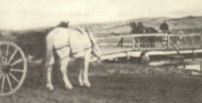
Working on the bridge over Loup River about 1 (1/2)
miles north of Mullen in the fall of 1890.
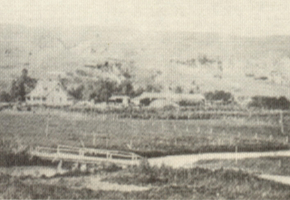
Bridge over Loup River about 1 (1/2) miles north of Mullen 1908.
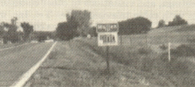
Entrance to Mullen 1987.
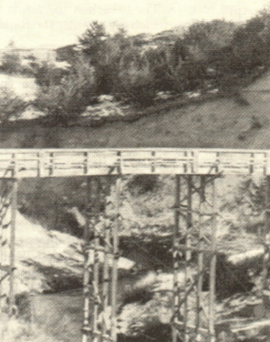
High bridge on the Dismal River built in 1921 by Louis Smidht.
The early roads in Hooker County were
sand trails, following the most accessible
routes through the hills. With increased
usage they became very soft and sandy,
making it difficult to travel with horse drawn
freight wagons and almost impossible to
travel with the first early model automobiles.
The road across Hooker County east to west,
following along the railroad tracks was
designated as the Potash Highway and
marked with signs with "PH". But it was still
largely an unimproved sand trail. The county
did have hay scattered on some of the softer
spots to make travel possible. Federal aid
became available for work on the Potash
Hiway in 1925. The first section of graveled
road was started from Hyannis, Nebraska
east.
ln 1926, the road was designated Nebraska
#2 Hiway and the old "PH" signs were
removed. The first Federal aid on Nebr. #2
in Hooker County was a 6 mile stretch
through Hecla in 1926-27. One of the prob-
lems of road building in this part of the
sandhills was that a sand grade needed a
surface of clay before being graveled. A clay
pit was found 2 miles west and 1 mile south
of Hecla. The clay, or "gyp" as it is called in
this area, was used from here for the con-
struction of Hiway #2 and the pit is still
owned and used by the Hooker County Road
Department. The road had been graded and
graveled to Mullen by 1928 and was extended
east of Mullen, following the Middle Loup
River to Seneca in 1932. The state put an oil
mat on Hiway #2 from Mullen west to Grant
County during 1931-32-33. The last section
of oil road from Mullen east to Thomas
County was completed in 1947.
After passage by the U.S. Congress of a
Federal-aid Hiway act in 1916, the Federal
government started planning a north-south
hiway to be called the "Great Plains High-
way". It was to go from Mexico to Canada.
The first surveyed route crossed Hooker
County from Tryon, Nebraska through Mul-
len and on north. Before any construction in
this area, the hiway was designated as U.S.
#83 and the route was moved east through
Thomas County. The State of Nebraska did
later designate a hiway #97 to go from Mullen
through Tryon to North Platte. The first
construction of this highway in Hooker
County was 4 miles of gravel road from
Mullen south in 1936. This was financed by
a government WPA program that hired local
residents with horses and scrapers to do the
dirt work and grading. Highway #97 has been
improved over the years to be an asphalt road
across the county from north to south.
One of the major problems of travel in
Hooker County was crossing the Middle
Loup to the north and the Dismal Rivers to
the south. There were few places the rivers
could be forded but particularly on the
Dismal, the crossing places were quite trea-
cherous.
At the July 21, 1890 meeting of the county
commissioners, the county was divided into
road districts, Mullen Precinct became road
district #1, Valley Precinct road district #2
and Abbey Precinct District #3. These areas
coincided with the Commissioner Districts.
At this time road supervisors or overseers
were appointed for each district. At this
meeting too, a motion was made to locate a
site and build a bridge across the Middle
Loup River north of Mullen as near as
possible to a line between sections 8 & 9
township 24, range 32. Bids were taken and
rejected August 16 and September 20, 1890,
but on October 23, 1890 a bid to build the first
Middle Loup bridge was awarded to Frank
Mary. The amount of the bid was $220. The
bridge was built that fall and on January 12,
1891 it was examined and approved by the
County Commissioners.
On July 20, 1891 a petition was presented
to the commissioners asking that a bridge be
built across the Dismal River. The commis-
sioners instructed surveyor C. Tucker to
locate a site. On July 25th, the county board
approved accepting bids for a bridge on the
north fork of the Dismal to be in the
northwest quarter of section 29, township 22,
range 32, and also a bridge on the south fork
of the Dismal in the southwest quarter of
section 29, T22, R32. Each of these locations
would have been about a mile west of the
forks of the Dismal where Hiway #2 pres-
ently crosses. On August 14, 1891, the
commissioners cancelled all bids in favor of
putting one bridge one mile east of the forks
of the Dismal. The bridge was to be at least
6 feet above the water, 40 feet long with a 12
foot roadway. September 21, 1891 a bid of
$298 by John Klinge was accepted and
George Mary was hired to build the ap-
proaches for $36. The bridge was built
between section 27 and T22 R32. June 29,
1892 the board accepted a bid by John Klinge
to build a bridge on the Dismal at Downings
Ford. April 1, 1897, the commissioners met
at the site of the first bridge east of the forks
on the Dismal and after examining it declared
it unsafe and hired Chas. Brannan to repair
it for $60. Apparently most of the early road
work consisted of bridges as the 1899 county
budget levied 4 mills for the bridge fund and
only 1 mill for road fund.
Very little road work was done by the
county prior to 1904. But after the Kincaid
act, more people settled in the county and
mail routes were established, so more road
work was needed. This consisted mostly of
paying residents to scatter hay on the
sandiest spots. Later the road over-seers were
authorized to buy hay and have it put on the
roads. In 1912 the county board purchased a
road scraper. About this time they started
hiring crews with 2 horse scrapers (called
slips) and 4 horse scrapers (called fresnos) to
do some grade work and surfacing on the river
hills approaching the county bridges.
The first major improvement of the county
roads came with the invention of the auto
gate or cattle guard. The county started
putting them in the fence lines on the county
mail routes so the mail carriers would not
have to open gates. Prior to 1904, there were
not many fences so gates were not a problem.
The first auto gates were made of 4 eight foot
bridge planks with holes drilled in them for
2 inch cross pipes about 6 inches apart. This
permitted motor vehicles to cross but not
livestock.
In the 1930's the county started improving
their road system by surfacing the sand trails
with clay and gravel.
In 1952, Hooker County built their first 8
miles of 12 foot wide asphalt road southwest
of Mullen. This road was built by Missouri
Valley Construction Co. using an experimen-
tal machine, called an "P & H", that mixed
the soil, aggregate and oil and laid a 12 foot
mat of asphalt road in one operation. The
project was financed by local donations that
matched Federal aid to Secondary Roads
funds.
By 1988, Hooker County was maintaining
approximately 30 miles of one lane 12 foot
asphalt road, 100 miles of narrow clay and
gravel roads and 13 miles of trail road. They
have approximately 165 steel auto gates in
use. The county also maintains two span type
bridges and one culvert type bridge on the
Middle Loup River, two culvert type bridges
on the north fork of the Dismal and two
culvert type bridges on the south fork of the
Dismal River.
"The High Bridge" on the Dismal attrac-
ted many sight-seers in it's time. March 20,
1918, the county board surveyed a site for a
bridge to span a narrow part of the canyon
walls at the forks of the Dismal River. They
awarded a contract to Lewis Schmidt to build
the bridge for $2058 plus 50 cents a foot for piling
and $50 per thousand board feet for lumber
put in place for wings. The bridge was to be
approximately 40 feet above the water and on
May 22, 1918, a State engineer approved the
plans. (See "SCHMIDT" for dimensions and
details of construction) . The bridge, and road
changes to it, was inspected and accepted by
Commissioners, J.L. Neal, Placer Tucker,
and W.G. Mitchell,. March 25, 1919. This
bridge that came to be known as "The High
Bridge" served many years and was a well
known landmark on the treacherous sand
trail from Mullen to Tryon. In 1955 they had
improved Highway #97 to an asphalt road
across the Dismal, just above the forks. The
two forks of the Dismal go under the oil road
by means of large metal flumes, the north
tributary flume is 216 feet long and the south
flume is 132 feet long. In November of 1955,
the county took bids for dismantling and the
removal of the old wooden "High Bridge".